 Import SHP File
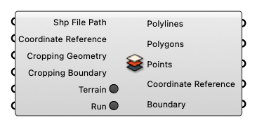
Import data from GIS shapefiles
Input
-
Shp File Path [Text]
Shp file path (.shp) -
Coordinate Reference [CR]
Coordinate reference information for properly locating the geometries in the Rhino canvas -
Cropping Geometry [Curve]
Cropping Geometry -
Cropping Boundary [Text]
A string representing geographical boundary. (Use 'Geo Boundary' component to get the string) -
Terrain [Boolean]
If turned on, the component will try to download corresponding terrain data files into the parent folderof the user-specified file path. -
Run [Boolean]
Run
Output
-
Polylines [Geometry list]
Polylines -
Polygons [Geometry list]
Polygons -
Points [Geometry list]
Points -
Coordinate Reference [CR]
Coordinate reference information for properly locating the geometries in the Rhino canvas -
Boundary [Text]
A string representing geographical boundary